Archive for the ‘LPSC’ category

Mars is gorges? Gullies @ LPSC

March 15, 2008

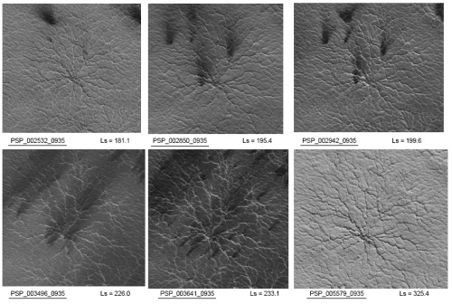
A half session at LPSC was devoted to observations and analog work on Martian gullies. These apparently young, water carved features are one of the many big puzzles on Mars today.
Credit: NASA / JPL/ U. Ariz.

Gullies, like the one shown above, were discovered on Mars back in 2000 in images taken by the Mars Orbiter Camera, the first high-res camera in orbit around the red planet. They were found in dune crests, crater walls, scarps, pretty much all over! Their age and origin was widely speculated on, but remained unclear. Then, in 2006, one gully was observed to change! Watch for the bright swath:

Credit: NASA / JPL / MSSS / Emily Lakdawalla

Of course, this caused all sorts of speculation on what had put the bright deposit in the channel, most of which was focused on the role of water. Pure water flows, water/ice slush flows, and mud flows were all cited as possible deposition mechanisms. Since then, dust avalanches have also been proposed. All of these, except dust flows, require water activity to be happening on Mars today. This lends support to the idea that there may be niches where water is metastable on the cold and super arid surface of Mars.

So where is the water coming from? The popular theory is snow melt. Dickson and Head briefly mentioned an analog for this on Earth: the Antarctic dry valleys, where regional and/or average climatic conditions are not conducive to snow melt, but gullies are actively forming!

Left: Antarctic Dry Valley gully. Right: Martian gully.
Credit: Fig. 1 from Martin et al. (2008).

Of course, the fluid probably isn’t pure water, but rather some combination of water, ice, and mud. Kate Coleman presented a series of scale model lab experiments where they compared the features created by liquid water flows to those created by icier “slush” flows, and the slush flows seemed to create features more like those we see on Mars.

If the fluid was mostly water, it might leave behind evaporites (salts, etc.), and we might expect to see an evaporite chemical signature in the new gully deposit. We haven’t, and although this might just be a resolution issue, something else might be going on. Jennifer Hardmann presented an analog study of mudflows in the super arid Atacama desert, and showed that mudflows can create the light-toned deposits like the one shown above. Mudflows are good particle sorters, and the finest particles tend to rise to the top of the flow. So, after the mudflow dries out and becomes dessicated, the flow will appear lighter toned because of the smaller particle size, but still has the same composition as the surrounding terrain.

What does Mars Taste Like?

March 15, 2008

Salt and vinegar potato chips.

Ok, not really: there are no potatoes on Mars. On the other hand, there is mounting evidence that Mars is and was a salty and acidic place. The salts are not generally table salt, and the acid was likely sulfuric rather than acetic, but you get the idea.

There were several talks today about experimenting with brines (salty solutions) to see if they could explain some of the observations of Mars. Jeff Moore described some ongoing experiments with salty solutions generated by mixing water with Mars soil simulants. He allowed the brines to evaporate under an atmosphere similar to the current Mars atmosphere (thing CO2) and also under an acidic SO2-based atmosphere that may better represent early Mars. By looking carefully at the sorts of crystals that formed, he showed that the brine that evaporated under an acidic, sulfur-rich atmosphere had more magnesium-sulfates, and matched more closely with the minerals seen by the Opportunity rover at Meridiani.

A second talk about salty solutions, given by Vincent Chevrier, studied how brines can act as antifreeze and permit liquid water on Mars. Currently the temperature and atmospheric pressure on Mars are too low, and water will either freeze or evaporate rapidly. However, anyone who lives in a wintry climate knows that salt can keep water liquid to temperatures well below zero. Chevrier showed that water mixed with sulfate salts can remain liquid down to temperatures of -72 degrees Celsius (-98 degrees Fahrenheit). He also showed that very salty solutions can reduce the rate of evaporation by up to 50 times. Chevrier suggested that this may mean that gullies on Mars are indeed formed by liquid water.

Carl Allen asked an excellent question following Chevrier’s presentation: If gullies are formed by these sulfate brines, shouldn’t we see sulfate signatures in the spectra? Chevrier said yes, but had not looked for the signature yet. He also suggested that the lack of a signature would not necessarily mean that brines were not involved because there are several plausible ways that the salty water could seep away, leaving the gully signature-free.

All of these serious laboratory studies are well and good, but really, the important thing here is that we have discovered a new Mars analog, and it’s available at your local supermarket!

5343365-19_12_2006-urbnosh28.jpg

Why is Mars Lopsided?

March 13, 2008

topography01.jpg

Take a look at this topographic map of Mars. The first thing that most people notice is that the northern hemisphere is mostly lower elevation (blue), and the southern hemisphere is mostly higher elevation (red). Nobody knows why. This “dichotomy” is one of the biggest questions in Mars science, and there were several talks yesterday afternoon trying to explain it.

There are two main types of theory to explain the Mars crustal dichotomy. One suggests that one or more giant impacts blasted away the crust in the north and left it lower than the south. The other theory relies on internal processes, such as motion in the mantle of Mars. It is possible to get a huge blob of less dense mantle to rise up in a “plume” that can change the thickness of the crust.

Herb Frey gave a talk suggesting that, based on the impact basins that we can see, the crust in the north must have been thinner even before the impacts occurred. He looked at two nearly identical basins, one in the north and one in the south, and showed that the crust under the northern basin was just too thin to be purely due to the basin formation. It must have been thin even before the impact that caused the basin.

How do we know how thick the crust is? It’s tricky. The general idea is that you watch how your spacecraft orbit the planet very very carefully. If the planet is a little more or less dense than average in a certain location, then it will change the gravity slightly, and therefore affect the orbit. With a bunch of assumptions about the density of the crust and mantle, you can come up with estimates of crust thickness.

Take a look at the topographic map of Mars again. The second thing that you’ll probably notice is a big blob of high elevation right on the equator between the southern highlands and the northern lowlands. This is the Tharsis volcanic bulge (you can see four huge shield volcanoes showing up as the very highest elevations).

Shijie Zhong gave an interesting presentation attempting to explain both the Tharsis bulge and the north-south dichotomy. He showed that, when you have really thick crust floating on the mantle, it forms a thick “keel” of rock that is more viscous than the mantle. This keel can interact with a large, upwelling mantle plume and actually can cause the planet’s crust to move as a solid shell! Zhong suggested that a large mantle plume may have formed the extra-thick southern crust, and then interacted with it, shifting the entire crust of Mars with respect to the plume until the plume was at the equator. Once the plume was beneath thinner crust, it could cause massive volcanism and form the Tharsis bulge.

Finally, Jeff Andrews-Hanna gave a really interesting talk suggesting that the northern lowlands are due to one huge impact very early in the history of Mars. To do this, he had to “remove” the Tharsis bulge. He did this by looking at crust thickness estimates. Unlike most of the crust on Mars which “floats” on the mantle, Tharsis is supported by the strength of the crust nearby. It’s similar to the way that you can have a stone bridge spanning a river with no support directly under the center of the arch, as long as the foundation on either side of the river is strong enough. Tharsis basically has no roots, it stays at high elevation because Mars has a thick crust that can hold it up. By understanding which parts of the crust are floating on deep “roots” and which parts are being supported, Andrews-Hanna made a map of the “roots” of the Martian crust. This map essentially removes Tharsis!

With Tharsis removed, you can trace the boundary between the lowlands and highlands all the way around Mars. Andrews-Hanna showed that this boundary matches an oval or elliptical shape that could be explained by a monstrous impact of a ~2000 km diameter object at a 45 degree angle. He even suggested that a region called Arabia terra may be the remains of a multi-ring structure in this ancient monster basin. Very cool stuff!

None of these talks are the final word on the origin of Tharsis or the north-south dichotomy, but they represent important steps in the right direction.

A Little Career Advice from Mike Griffin

March 12, 2008

If you haven’t heard, the NASA Mars Exploration Program budget is in a bit of a tight spot.

The budget for the next 12 years was already going to be tricky, with the cost overruns of MSL, the delay of the 2011 Scout mission, and plans for the uber expensive 6-missions-in-1 Mars Sample Return. Now, because NASA is moving money to Outer Planets to fly a new flagship mission, the Mars budget is being slowly, and somewhat painfully, reduced, back down to the program’s 25 year average. And not just for the next funding cycle – this plan stretches through the next decade.

The rationale, according to NASA Administrator Mike Griffin during his talk at LPSC on Monday, is that there’s a fixed amount of money in the NASA budget, and that ramping up efforts in one program means we have to reduce another. In other words, Mars can’t maintain its high funding levels if we want to do other things. In Mike Griffin’s words, “the sun don’t shine on the same dog all the time.”

Brown University grad student Bethany Elhman brought up a great point, and one that’s been bothering me ever since they announced the funding cuts. The idea that we have to shuttle money around between different planetary programs means that each individual program, e.g. Mars, will experience cyclic funding cycles, on the scale of decades.  Unfortunately, this means that it’s nearly impossible to maintain a critical mass of scientists in a particular program, and that the community has to play catch-up every time the cycle starts again.  This is particularly worrying to young people (like us) just starting out in our careers in Mars research, since we’re developing specialized skill sets that may be useless (and unemployable…) in 5 years.

Mike Griffin’s response? “Don’t specialize.”

Ok, so that’s great if you’re an established scientist with lots of connections and an established reputation, but what kind of message is that to send to grad students? A PhD requires the most ridiculous degree of specialization – you have to become the world’s expert on a microcosm of a microcosm. There’s no other way to establish that reputation. And frankly, the idea of accomplishing that insane feat just to never use that knowledge again is a little discouraging.

I’ve been told the oil industry is so rich that it’s hiring anyone with a geology background… is NASA going to make me sell my soul to Exxon-Mobil?

… Not that I’m really that worried. Part of the beauty of planetary science is the possibility of being able to work on many different problems in different places – but I’d prefer to wait until after my dissertation to think about diving into that.

Martian Greenhouse: Volcanic CO2 Doesn’t Cut It

March 12, 2008

With all the evidence for water on the surface of Mars in the distant past, we always return to the same question: how was it possible for water to be stable back then? These days any liquid water on the surface would boil due to the low pressure or freeze due to the low temperature (or maybe do both at the same time!).

To explain liquid water on the past, there has been a lot of work done to see whether a thicker atmosphere of CO2 could provide high enough pressure and temperature to allow stable water. Today Marc Hirschmann gave an interesting talk about whether volcanoes could give off enough gas to do the job.

It turns out that since the sun was dimmer in the past, and since Mars is farther from the sun than the Earth, the early CO2 atmosphere of mars would have to be several times as thick as Earth’s current atmosphere to keep liquid water stable at the surface. Hirscmann estimated how much volcanism there was on Mars based on the heat flow from the planet, and then calculated the amount of CO2 released based on the amount of carbon in the mantle. Hirschmann showed that on Mars, with the amount of oxygen available to react with rocks (the so-called “oxygen fugacity”), the carbon in many lavas would likely be in the form of graphite, or even diamonds deep in the mantle where the pressure is higher.

With reasonable estimates of the amount of volcanism and the amount of carbon in the lavas, Hirschmann estimated that even in the “best case” scenario, volcanism can only provide an atmosphere with 0.1 bars of CO2: only a tenth of Earth’s atmospheric pressure and not nearly enough to make Mars warm. This led Hirschmann to look at the possibility of CO2 from the formation and stabilization of the crust. Depending on the assumptions you make, this process can give either 10s of bars of CO2, or a negligible amount.

Hirschmann concluded that if crust formation was the source of a thick atmosphere, it would require the most extreme limits of likely conditions. Alternatively, a CO2 atmosphere could have somehow persisted from the very earliest period of martian evolution, when the planet had a “magma ocean”. Alternatively, there may have been a greenhouse effect caused by something other than CO2, such as SO2 or methane. This “alternative greenhouse gas” idea is pretty new, but it shows a lot of potential for explaining a warm early climate. I don’t know enough about it yet to post intelligently, but if I learn more, I’ll share it here.

Ok, back to the talks!

Impacts, Occam’s Razor, and Layers

March 12, 2008

The final Mars talk that I saw yesterday came at the end of a session rich with discussion of geochemistry, aqueous alteration, hydrothermal systems, and reference to the ubiquitous layers seen by both Mars rovers as being emplaced, or at least altered, by water. So I was interested to hear that the final presenter, Don Burt, has an alternative hypothesis.

Burt suggested that since layers are so ubiquitious, and that they are seen at both landing sites, we should not invoke multiple unique, complicated scenarios to explain them, when there is a simple one that could do the job. He think that flows of debris from impact craters, called “base surge”, could explain everything that is seen. He says that the cross-bedding (slanted layers that intersect each other) that is observed was also commonly seen in sand around nuclear test sites, and is seen in the remains of volcanic explosions. He also pointed out that it is easy to form spherical particles similar to the famous “blueberries” at Meridiani in a turbulent cloud of impact surge.

His hypothesis is an unpopular one, and has some serious issues. It doesn’t explain the chemistry of the rocks, and the sorts of spherules formed in “base surge” should be randomly distributed, not evenly spaced like the blueberries. Also, he said that the blueberries are blue-grey, while similar water-formed concretions on Earth are reddish. The blueberries are not blue. They are jus tless red than the rest of the dusty martian surface, so they show up as blue in false color images.

Burt claimed that his impact layer hypothesis is simplest, and therefor the best. This line of reasoning is often called “Occam’s Razor”. Unfortunately, I think Burt falls into the trap of making things too simple. There is a famous quote (or paraphrased quote) from Einstein that sums this up: “Everything should be made as simple as possible, but not simpler.”

Despite the many problems of the impact hypothesis, I was glad to see Burt’s presentation. What good is science if we all just get up and agree with each other? He also had some very good points, particularly that it is dangerous to assume that Mars was or is earth-like. That sort of assumption can lead to unintended biases and clouded judgment. Obviously, we have to assume that processes on other planets work similar to those seen on our own: that’s basic comparative planetology. But we have to be careful not to “force” Mars into an earth-like mold.

Burt’s talk was not popular, and his hypothesis will probably not be picked up by many people, but I think it is a good sign that there are the occasional voices going against the crowd. Sometimes those voices are correct and everyone else is wrong, and that’s how progress is made.

Spiders on Mars?!

March 12, 2008

Yes, it’s true –there are multi-legged, creepy-crawly looking things on Mars. The HiRISE camera has taken pictures of a slew of these things. But don’t worry, arachnophobs – they won’t bite or lay eggs under your skin at night. They’ll just spit.


The “spiders” are actually systems of channels near the south pole of Mars, as Dr. Candy Hansen explained during one of this morning’s LPSC sessions. These channels radiate outward from a central point (hence the spideriness), and they’re covered with a layer of translucent carbon dioxide ice. When sunlight starts to heat the bottom of that ice layer, the carbon dioxide sublimates into a gas, mixes with some surface dust, and gets spewed up from the channel through a crack in the ice. So you could say that the spiders spit from their legs.


In this series of pictures, HiRISE captured the same spider at different times of the year:

Spiders on Mars

The dark splotches are the spider “spittle”. You’ll notice that those dark trails change directions – that’s because when the gas and dust shoots up, the wind carries the plume, and the dust gets laid down onto the surface in whichever direction the wind was blowing. If the wind changes direction, the dust gets deposited in a different way.


Fascinating! This is great science and an amazing discovery, but I have a bone to pick with the presenters: Dr. Hansen said that the term “spiders” was too colloquial, and asked the scientific community to start calling them “araneiforms.” I like the term “spiders” – it’s easy to say, easy to spell, and easy to visualize. “Araneiforms” is none of those things. I always thought that most scientists used excessive jargon because they didn’t know how else to communicate (I gave them the benefit of the doubt). But here’s an example of scientists inventing jargon for the express purpose of sounding more scientific – and in the process making their discovery less accessible to a lay audience.


To prove my point: would you have been as interested in reading this post if I had called it “Araneiforms on Mars?!” (don’t answer if you’re a scientist).


Networking the Moon

March 12, 2008

This afternoon I was listening to Mars talks about geochemistry, but I reached saturation. I had to go hear about somewhere else in the solar system. So, I wandered in a stupor over to the session on lunar exploration. It turns out I had good timing: I got there just in time to hear none other than Alan Stern, associate administrator of NASA’s science mission directorate, give a talk about the International Lunar Network.

The gist of his presentation was this: a lot of countries are interested in sending missions to the moon in the next couple decades. If we’re all going there, we might as well coordinate so we can maximize the science. He pointed out that a lot of missions to the moon have extra room to carry “piggyback” missions on the same rocket, which means that
you can essentially send a big mission and a smaller one every launch. For example the GRAIL mission will carry a small orbiter called LADEE (I forget what the acronym stands for…), which will measure the state of the moon’s “atmosphere”. The idea is: once a bunch of rockets are landing on the moon, there will be tons of rocket exhaust floating around which will muck up detection of the actual (extremely tenuous) atmosphere. Cool!

So, back to the networks. Stern’s talk basically proposed that, when countries send landers to the moon, either on their own rockets, or as piggybacks on other mission, they cooperate to have a standard “core” set of instruments. That way you can do unique science, like setting up a earthquake detectors in multiple places, or radiation detectors, instruments to measure the amount of heat coming from the ground, etc. These sorts of measurements are much more powerful if you can record the same sorts of data at multiple locations at once.

Stern said that NASA has requested money to carry out science investigations, and will pledge to send two landers to serve as “hubs” for the proposed network of landers. He also said that there had been talk of NASA providing a communications satellite that all nations in the International Lander Network could use to relay data back to earth, even from the far side of the moon.

I think this is a great idea , both for the science potential, and the international cooperation involved. Stern said that the first meeting of international partners on the network would be tomorrow, and they had dates in mind for deciding what the “core” instruments would be, and for nations to sign up to be a part of the network. It sounds like this is well on its way, and I’ll be watching for news as it changes from an idea to actual missions.

moon010228.jpg

Layers and Swiss Cheese

March 11, 2008

No, this isn’t a post about sandwiches. There just happen to be layers and swiss cheese (terrain) in the ice caps on Mars.

The morning session that I attended today was all about the north and south polar ice caps, and what people are seeing there, especially with new high-resolution data. The poles of Mars are really interesting because every winter the atmosphere condenses out to form layers of carbon dioxide and every summer those layers sublimate away.

One of the first talks I saw this morning was by Kathryn Fishbaugh, about tracing layers in the north polar cap with very high resolution HiRISE images, and the digital elevation models (DEMs) that can be made from those images. DEMs work on the same priciple as depth perception: using two slightly different points of view (one from each eye) your brain can construct a 3D view of the world around you. Similarly, using images taken from slightly different locations in orbit, scientists can make really high resolution topographic maps. Fishbaugh used these maps, and the images from HiRISE, to identify important “marker” layers that are easy to follow over long distances in the north polar cap. She found that the spacing of these thick layers might correspond to changes in the way that Mars tilts. The tilt of a planet can drastically change its climate, and Mars can change from spinning nearly vertically to nearly tipping over on its side (tilting up to nearly ~60 degrees sometimes).

Another talk by Wendy Calvin showed that even where the north polar caps look dark, there is evidence for ice. Everywhere they look with CRISM, light and dark layers both have ice in them. The dark layers might just have a little more dust. Dust can acti like a pigment, and a little bit can make a big difference in the color of the surface.

Moving on to the south pole, Shane Byrne gave a cool talk about explaining the “swiss cheese” terrain that is seen in the carbon-dioxide ice at the south pole. To give you an idea of why it is called “swiss cheese” terrain, take a look at this:

psp_004778_0945.jpg

In the picture, the really smooth area is higher up. It is part of a slab of dry ice that is gradually turning back into gas. As it sublimates, the terrain develops really weird textures: the lower-elevation pits in the CO2 layer are like holes in a slice of swiss cheese. Byrne came up with a computer model that shows that, weird though it may look, the swiss cheese terrain is just the result of normal cycles of deposition and sublimation of carbon dioxide. The cycle works like this: start with a flat area and start depositing dry ice on it from the atmosphere. Inevitably, there will be some places that get a little more than other places, and the surface will become more rough. Once roughness gets started, it will become exaggerated as more CO2 is added (maybe a rough spot that gets less sunlight will accumulate a litte more CO2). Eventually, pits form in the CO2 layer where more CO2 sublimates than condenses. Once the pit reaches through the CO2 layer, it grows and grows, until it meets up with other pits and eventually the CO2 layer is eaten away. Pretty cool stuff. A key factor in his models is that dust storms can change the rate at which CO2 is deposited, so they can have a big influence on how the swiss cheese terrains form and evolve.

There was a talk about Martian spiders too, but I’ll let Melissa fill you in on that one.

Lunar and Planetary Science Conference XXXIX

March 9, 2008

We are heading down to Texas today for the 39th Lunar and Planetary Science Conference (LPSC)! This conference is one of the biggest annual gatherings of planetary scientists, and there are sure to be lots of interesting results. We will do our best to cover the highlights while we’re there and post about them here. If you’re interested, you can browse the abstracts at this link.
Stay tuned for loads of planetary news!